
Close menu
- Home
- Market Reports
- Product Reports
- News
- Companies
- Topics
- Events
- Subscribe


C-MAP updates North America cartography
By Craig Ritchie2024-02-28T12:55:00
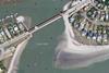
New chart data includes greater detail, upgraded satellite imagery and new clearance data for bridges and locks
To continue reading this article…
Already registered?
Create a FREE account
To continue reading this article you must
register for a free account and login.
Subscribe to IBI Plus
Subscribe today and recieve
instant unlimited sitewide access.
- Subscribe
- Print Issues
- Topics A-Z
- Contact us
- Terms and Conditions
- Privacy Policy
- Cookie Policy
- © 2026 BOAT INTERNATIONAL MEDIA LTD.
 LinkedIn
 X / Twitter
 Facebook
 Email us
- Members of:
-
-
-
-

- Partners with:
-

-
- © 2026 Boat International Media Ltd.
- Topics A-Z
- IBI Magazine
- Terms & Conditions
- Privacy Policy
- Cookie Policy
- Subscribe
- Contact us
Site powered by Webvision Cloud